AutoGArrows - GPS based navigation plugin for Panotour
Here is AutoGArrows plugin for Panotour.
Information about AutoGArrows plugin for krpano can be found on this page.
AutoGArrows - is a plugin for Panotour, which makes navigating the tour automatically based on the GPS coordinates of the panoramas.
What is required for the plugin to work
1. Panoramas with GPS coordinates
2. Panoramas must be correctly aligned relatively to virtual North or contain correct EXIF GPSImgDirection tags
3. GArrows plugin must be installed and KEEPVIEW mode is enabled
If there is no GPS coordinates
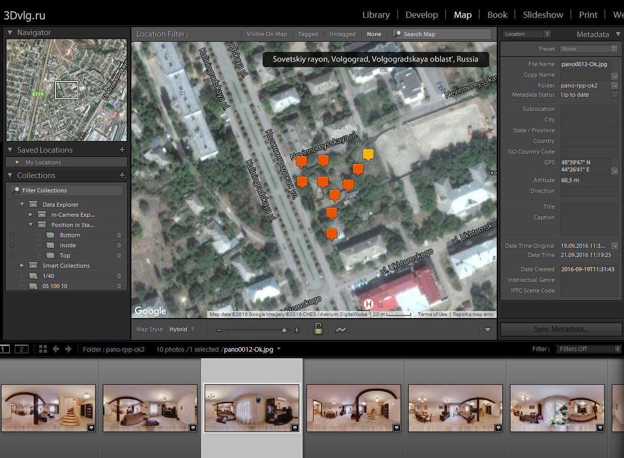
GPS coordinates must be assigned to each panorama. You can use LightRoom, placing the panoramas on the map using MAP tab. Compliance geographic coordinates of the panoramas with actual place of shooting does not matter, the right relative positions of the panoramas on the map is important.
Also you can use program like GeoSetter to synchronize panoramas with recorded GPS track
About virtual North
If the center of each panorama has a constant bearing on the real North that panoramas are aligned correctly. The presence of the same virtual North in the panoramas is very important for the tours with the routes. For these tours KEEPVIEW mode is required. How to shoot and stitch panoramas with the same virtual North you can find on the Robostitcher's home page.

If the panoramas does not have the same virtual North, you need to align them using PTGui, Offset filter in Photoshop or use Panotour building function.
For panoramas taken by spherical cameras you may not align panoramas. Please read information about scenes GPSImgDirection values setting below.
Building the tour with the Panotour PRO
Panoramas with a GPS tags in the Panotour marked with an appropriate icon.
It is necessary to enable KEEPVIEW mode in the GArrows plugin settings

Set the search radius within which the panoramas will be considered as neighbors and will be linked. Set the azimuth correction.
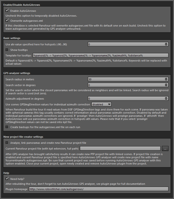
Azimuth correction - the number of degrees which will allow to align the virtual North of the panoramas and the real North on the map (terrain).
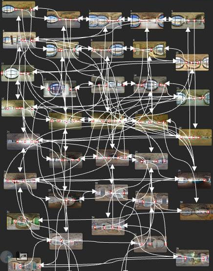
Click Build tour and open the tour in your browser. There is no navigation yet! To AutoGArrows built the navigation AutoGArrows GPS analyser must be used. To AutoGArrows GPS analyser links the panoramas you need to run it with the project scenes XML file as a parameter. You were familiar with this file when determining navigation hotspots style for GArrows plugin. The video below explains how to use AutoGArrows GPS analyzer (starting version 0.23 use exe file instead of bat, shown in the video)
If after working AutoGArrows GPS analyser arrows are missing, the search radius must be increased. If there are too many, then reduce. Statistics after each run will be a good starting point for more precise radius tuning.
By adjusting the radius of the search neighboring panoramas and azimuth correction, you may need to run AutoGArrows GPS analyser several times. After the first run AutoGArrows GPS analyser create batch file (graphics/autogarrows/autogarrows.xml.bat for Windows and graphics/autogarrows/autogarrows.xml.sh for MAC OS) in order not to use the Drag & Drop every time. Just run it after make changes to the plugin settings in the Panotour.
AutoGArrows GPS analyser creates an XML file graphics/autogarrows/autogarrows.xml with comments in the current tour folder. You can remove extra links from this file or create a missing using Panotour and GArrows.
Basic workflow with Panotour
If the panoramas does not have the same virtual North you may align them using Panotour. After you loaded all panoramas align each of them to real North
When done set Azimuth adjustment to 0, set Use scenes GPSImgDirection values for individual azimuth correction to prealign or athshift (better if project file creation is enabled). Set search radius or search sector depending your needs and build the tour.
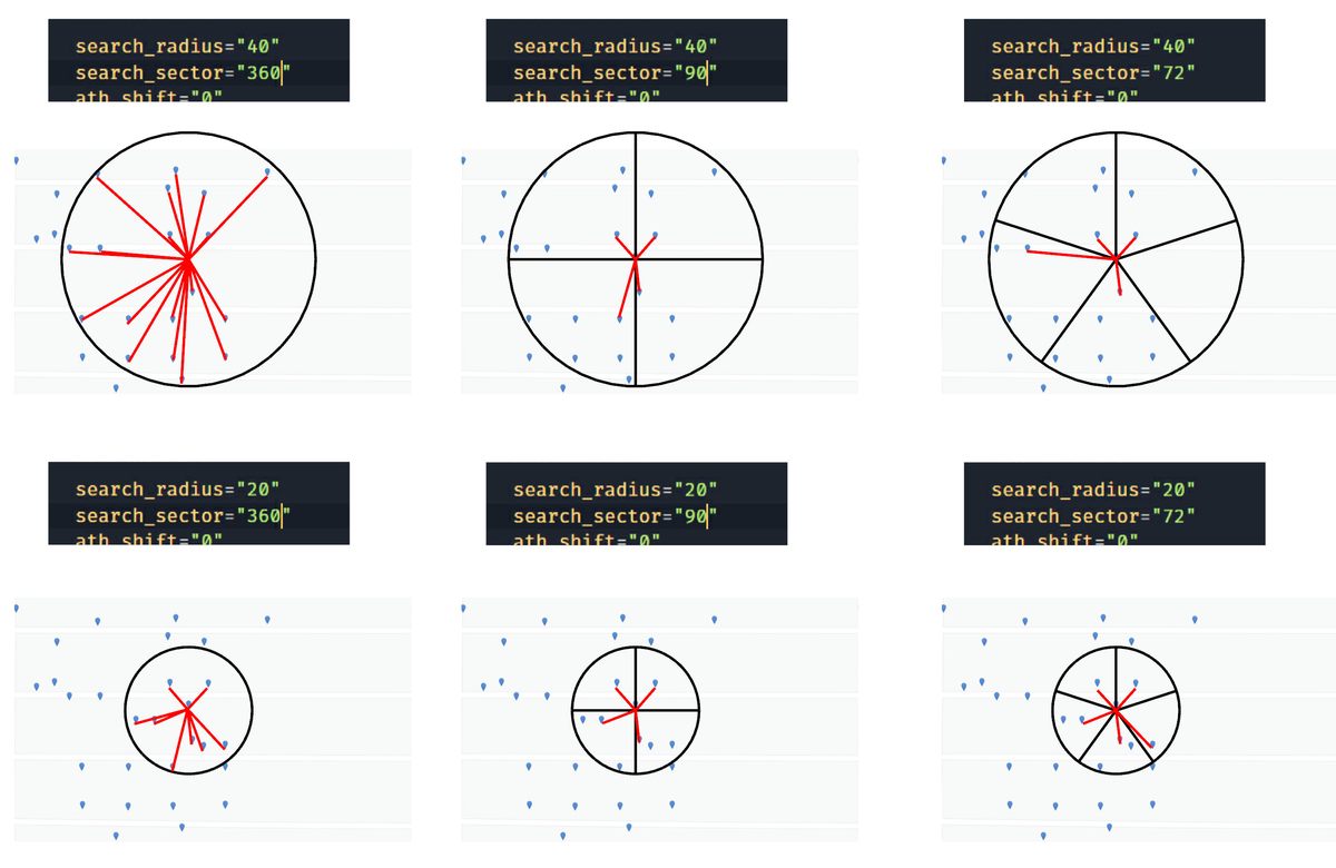
About search by radius and search by sectors

If Search sector is defined then 360 space around every scene will be divided by sectors and only closest panorama in the each sector will be considered as neighbor and will be linked. In this case Search radius will be ignored

About scenes GPSImgDirection values
When Panotour build the tour it read values from EXIF GPSImgDirection tags and store them for each scene. If panorama was taken with spherical cameras this tag usually contains correct information about panoramas azimuth correction. Disabled by default and individual panoramas azimuth corrections are ignored. If 'prealign' then AutoGArrows will prealign panoramas. If 'athshift' then AutoGArrows will use panoramas azimuth correction in hotspots ath values. You must enable it if you are using Panotour to align panoramas to the real North. Please note that if you select 'prealign' GPSImgDirection values can not be saved into kpt file.
Panoramas from some cameras (Samsung Gear 360, for example) do not cantain GPSImgDirection tag, but contain PoseHeadingDegrees wich is the same, but ignored by Panotour. In this case you need to use tiny script from panoexif to copy PoseHeadingDegrees values to GPSImgDirection tags before building the tour with Panotour.
Saving Panotour project with linked scenes
After GPS analyzer has brought satisfactory results you can use it to create new project file. If project file creation is enabled and current Panotour project file name is specified in the AutoGArrows settings, AutoGArrows GPS analyser will create new project file with name %currentname%-autogarrows.kpt
Be sure that current project was saved before running AutoGArrows GPS analyser in this mode. After GPS analyser done its work, close current project, open newly created file and remove AutoGArrows plugin from the project. You can even remove GArrows, created links will remain untouched.
Now you can add missing links or remove extra links using Panotour in the usual way.
It is highly recomended to use this mode with new projects with only GPS tagged panoramas loaded. After you check and correct navigation hotspots you can add additional plugins and do the further work.
AutoGArrows GPS analyzer available for Windows and MAC OS
There is some difference on using GPS analyser on Windows and MacOS. On MacOS you need to use terminal to launch GPS analyser. Look at the video https://www.youtube.com/watch?v=_NZfFFXJIKo
The familiar picture? Forget it!
Have questions?
Ask a question or search for an answer in the official AutoGArrows plugin's group on Facebook. Please PM me with questions about payments and downloads.
Download AutoGArrows for Panotour demo
Fully functional demo versions of the AutoGArrows with AutoGArrows GPS analyzer can be downloaded here.
- Download AutoGArrows plugin with AutoGArrows GPS analyzer for Windows and MAC OS
Download AutoGArrows for Panotour
AutoGArrows with AutoGArrows GPS analyzer for both Windows and MAC OS can be downloaded from Google drive after donation or from the MyCommerce cloud server instantly after purchase
Attention. Since December 20, 2016 Google Drive sometimes began to find "viruses" in the archives of the program and warn of the possibility of infection. This behavior has spread to all AutoGArrows releases, including uploaded before this date. Perhaps the situation will be corrected in the near future, but for now, download, check by local antivirus program and use.
If you like AutoGArrows please purchase

50 USD fixed price
Link to download AutoGArrows for Panotour will be provided instantly after purchase
4650 RUR fixed price
Link to download AutoGArrows for Panotour will be provided within few days
AutoGArrows - GPS based navigation plugin for Panotour
AutoGArrows - GPS based navigation plugin for Panotour
Here is AutoGArrows plugin for Panotour.
Information about AutoGArrows plugin for krpano can be found on this page.
AutoGArrows - is a plugin for Panotour, which makes navigating the tour automatically based on the GPS coordinates of the panoramas.
What is required for the plugin to work
1. Panoramas with GPS coordinates
2. Panoramas must be correctly aligned relatively to virtual North or contain correct EXIF GPSImgDirection tags
3. GArrows plugin must be installed and KEEPVIEW mode is enabled
If there is no GPS coordinates
GPS coordinates must be assigned to each panorama. You can use LightRoom, placing the panoramas on the map using MAP tab. Compliance geographic coordinates of the panoramas with actual place of shooting does not matter, the right relative positions of the panoramas on the map is important.
Also you can use program like GeoSetter to synchronize panoramas with recorded GPS track
About virtual North
If the center of each panorama has a constant bearing on the real North that panoramas are aligned correctly. The presence of the same virtual North in the panoramas is very important for the tours with the routes. For these tours KEEPVIEW mode is required. How to shoot and stitch panoramas with the same virtual North you can find on the Robostitcher's home page.
If the panoramas does not have the same virtual North, you need to align them using PTGui, Offset filter in Photoshop or use Panotour building function.
For panoramas taken by spherical cameras you may not align panoramas. Please read information about scenes GPSImgDirection values setting below.
Building the tour with the Panotour PRO
Panoramas with a GPS tags in the Panotour marked with an appropriate icon.
It is necessary to enable KEEPVIEW mode in the GArrows plugin settings
Set the search radius within which the panoramas will be considered as neighbors and will be linked. Set the azimuth correction.
Azimuth correction - the number of degrees which will allow to align the virtual North of the panoramas and the real North on the map (terrain).
Click Build tour and open the tour in your browser. There is no navigation yet! To AutoGArrows built the navigation AutoGArrows GPS analyser must be used. To AutoGArrows GPS analyser links the panoramas you need to run it with the project scenes XML file as a parameter. You were familiar with this file when determining navigation hotspots style for GArrows plugin. The video below explains how to use AutoGArrows GPS analyzer (starting version 0.23 use exe file instead of bat, shown in the video)
If after working AutoGArrows GPS analyser arrows are missing, the search radius must be increased. If there are too many, then reduce. Statistics after each run will be a good starting point for more precise radius tuning.
By adjusting the radius of the search neighboring panoramas and azimuth correction, you may need to run AutoGArrows GPS analyser several times. After the first run AutoGArrows GPS analyser create batch file (graphics/autogarrows/autogarrows.xml.bat for Windows and graphics/autogarrows/autogarrows.xml.sh for MAC OS) in order not to use the Drag & Drop every time. Just run it after make changes to the plugin settings in the Panotour.
AutoGArrows GPS analyser creates an XML file graphics/autogarrows/autogarrows.xml with comments in the current tour folder. You can remove extra links from this file or create a missing using Panotour and GArrows.
Basic workflow with Panotour
If the panoramas does not have the same virtual North you may align them using Panotour. After you loaded all panoramas align each of them to real North
When done set Azimuth adjustment to 0, set Use scenes GPSImgDirection values for individual azimuth correction to prealign or athshift (better if project file creation is enabled). Set search radius or search sector depending your needs and build the tour.
About search by radius and search by sectors
If Search sector is defined then 360 space around every scene will be divided by sectors and only closest panorama in the each sector will be considered as neighbor and will be linked. In this case Search radius will be ignored
About scenes GPSImgDirection values
When Panotour build the tour it read values from EXIF GPSImgDirection tags and store them for each scene. If panorama was taken with spherical cameras this tag usually contains correct information about panoramas azimuth correction. Disabled by default and individual panoramas azimuth corrections are ignored. If 'prealign' then AutoGArrows will prealign panoramas. If 'athshift' then AutoGArrows will use panoramas azimuth correction in hotspots ath values. You must enable it if you are using Panotour to align panoramas to the real North. Please note that if you select 'prealign' GPSImgDirection values can not be saved into kpt file.
Panoramas from some cameras (Samsung Gear 360, for example) do not cantain GPSImgDirection tag, but contain PoseHeadingDegrees wich is the same, but ignored by Panotour. In this case you need to use tiny script from panoexif to copy PoseHeadingDegrees values to GPSImgDirection tags before building the tour with Panotour.
Saving Panotour project with linked scenes
After GPS analyzer has brought satisfactory results you can use it to create new project file. If project file creation is enabled and current Panotour project file name is specified in the AutoGArrows settings, AutoGArrows GPS analyser will create new project file with name %currentname%-autogarrows.kpt
Be sure that current project was saved before running AutoGArrows GPS analyser in this mode. After GPS analyser done its work, close current project, open newly created file and remove AutoGArrows plugin from the project. You can even remove GArrows, created links will remain untouched.
Now you can add missing links or remove extra links using Panotour in the usual way.
It is highly recomended to use this mode with new projects with only GPS tagged panoramas loaded. After you check and correct navigation hotspots you can add additional plugins and do the further work.
AutoGArrows GPS analyzer available for Windows and MAC OS
There is some difference on using GPS analyser on Windows and MacOS. On MacOS you need to use terminal to launch GPS analyser. Look at the video https://www.youtube.com/watch?v=_NZfFFXJIKo
The familiar picture? Forget it!
Have questions?
Ask a question or search for an answer in the official AutoGArrows plugin's group on Facebook. Please PM me with questions about payments and downloads.
Download AutoGArrows for Panotour demo
Fully functional demo versions of the AutoGArrows with AutoGArrows GPS analyzer can be downloaded here.
- Download AutoGArrows plugin with AutoGArrows GPS analyzer for Windows and MAC OS
Download AutoGArrows for Panotour
AutoGArrows with AutoGArrows GPS analyzer for both Windows and MAC OS can be downloaded from Google drive after donation or from the MyCommerce cloud server instantly after purchase
Attention. Since December 20, 2016 Google Drive sometimes began to find "viruses" in the archives of the program and warn of the possibility of infection. This behavior has spread to all AutoGArrows releases, including uploaded before this date. Perhaps the situation will be corrected in the near future, but for now, download, check by local antivirus program and use.
If you like AutoGArrows please purchase
50 USD fixed price
Link to download AutoGArrows for Panotour will be provided instantly after purchase
4650 RUR fixed price
Link to download AutoGArrows for Panotour will be provided within few days